

Large Scale Farm Scene Modeling from Remote Sensing Imagery
SessionModeling and Reconstruction
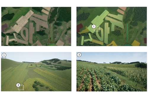
DescriptionIn this paper we propose a scalable framework for large-scale farm scene modeling that utilizes remote sensing data, specifically satellite images. Our approach begins by accurately extracting and categorizing the distributions of various scene elements from satellite images into four distinct layers: fields, trees, roads, and grasslands. For each layer, we introduce a set of controllable Parametric Layout Models (PLMs). These models are capable of learning layout parameters from satellite images, enabling them to generate complex, large-scale farm scenes that closely reproduce reality across multiple scales. Additionally, our framework provides intuitive control for users to adjust layout parameters to simulate different stages of crop growth and planting patterns. This adaptability makes our model an excellent tool for graphics and virtual reality applications. Experimental results demonstrate that our approach can rapidly generate a variety of realistic and highly detailed farm scenes with minimal inputs.
Event Type
Technical Papers
TimeFriday, 6 December 202410:56am - 11:08am JST

LocationHall B5 (1), B Block, Level 5


